4. To what extent is water scarcity in Almeria a problem of timing rather than volume?
- Organically Written by a human without AI generation
The Volume and intensity of rainfall in the Almeria region is known to be deadly on occasion, with 6.9% of Spain’s population living in flood-prone areas (Published in Characterization of extreme flash floods in Mediterranean Spain). Despite this, water is again being authorised this year to be supplied from the Negratin reservoir indicating that the amount of water stored will not be sufficient to see the farmed crops through to harvest this year (El Negratin volverá a enviar Agua a Almería tras casi cinco años). So, the question “To what extent is water scarcity in Los Menas a problem of timing rather than volume?” is valid. Here I present why I think it is a combination of precipitation levels, the amount and concentration of that precipitation over the year, the conditions of the surface it interacts with and what the combination of these factors mean when combined.
Precipitation levels
The area receives little rainfall on average due to the geography, being in the rain shadow of the Sierra los Filabres and inland from the sea. 300mm of rainfall per year makes it semi-arid- arid by definition and drives a reliance on groundwater pumping and imported water from wetter regions further north and west in the country.
Concentration of precipitation over time
Considering the Almanzora valley and Almeria based on its precipitation levels (circa 300mm per year- Average Monthly Rainfall in Huércal-Overa | Rainfall Graphs), it could be advantageous to have wet and dry cycles as opposed to the yearly rainfall spread evenly over the year - although not to the extremes we experience. If the rainfall were equally spread out throughout the year, it could be that there is never enough where it’s needed in one go to fully saturate the ground and sink down to a level useful for any groundwater recharge before the sun and dry warm winds can do their work on evaporating it. The plant life in the region is adapted to semi-arid conditions, so it benefits from wet/dry cycles as they are.
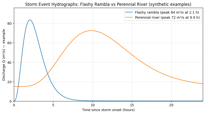
A hydrograph showing the river flow rates of a storm in a rambla river basin vs a perennial river
A hydrograph for the area plotting the flow rate of water and a hyetograph shows precipitation in a storm event against time on the X and Y axis. Combining the two by also plotting the river discharge would typically trend showing extremely low baseflow, a sharp precipitation increase over a short period known as the Rising Limb on the hydrograph, then a large, lagging flood peak. The lag time indicates the time it takes for the runoff to flow down into the river basin aided by factors such as runoff coefficient, gravity, drainage shapes in the landscape, Soil makeup & texture, landscape roughness and existing moisture levels in the soil prior to the storm. which then dissipates more gradually as the flooding subsides (the recession limb). Before returning a little more gradually down to the baseflow again.
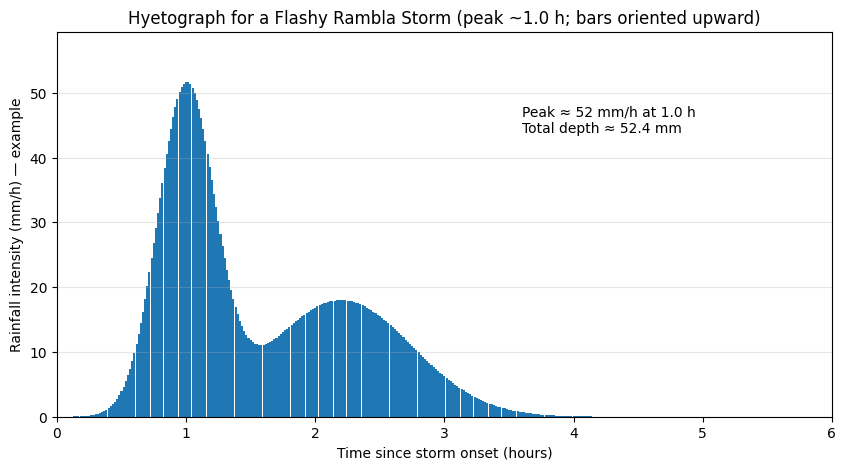
An example of a Hyetograph of the same river showing a flash flood event caused by a storm
Ideally, if all precipitation could be collected in underground cisterns and basins, it would allow particulates to settle before the water is used for irrigation during dry periods of the year. If you were to slowly release the same amount of water in a controlled and efficient manner such as drip irrigation rather than flooding fields and that stored water was irrigated under vegetated ground cover then it would go a lot further. This hypothetical scenario would in effect be reducing the sharp angle of the recession limb.
Surface conditions
Bare ground with its high run off coefficient means that water when it does fall doesn't sink in, rather it runs off like it does on tarmac roads into drains, substrate like sun baked clays are the worst for this, and the sandier the surface layer is the better in terms of deeper infiltration. (A review on the prevention and control of flash flood hazards on a global scale: Early warning systems, vulnerability assessment, environmental, and public health burden)
Due to the lack of a substantial layer of topsoil, and that which is there typically being dry from its daily exposure to the sun, the surface is hydrophobic and unable to hold much of the water that hits it. Were it to have enough vegetation or resistance to slow the flow of water and sink it in, a soil layer could be built. But it doesn’t. dust and smaller particulates get washed down into the ramblas and deposited for baking by the sun once the floods subside.
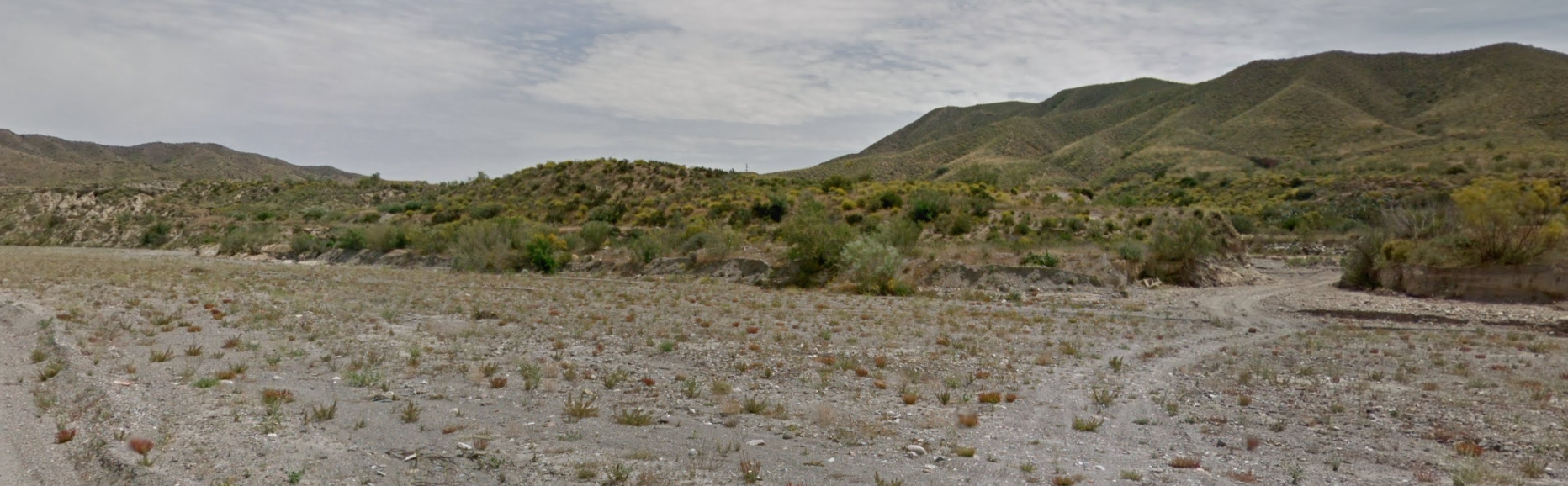
A google maps view of an area taken in may so following the rainy season, showing the potential for vegetation to take hold, prior to the summer. Notice the clear path from the hills down to the rambla itself which is a channel for the heavy stormwater flashes.
Further to this, the land in the region is farmed intensively so isn’t designed and managed with water storage in mind, rather urbanisation opts for efficient drainage to avoid property damage. Making flood waters somebody else’s problem further downhill. This usually causes heavy erosion of accumulated topsoil and damages the landscape; floodwater is treated as a hinderance rather than an asset. (Butzer-2005-EnviroHistMedWorl - Env History degradations and soil erosion)
The combination of the factors
Ultimately, scarcity and drought is a result of the combinations of the factors above for the annual cycle, although precipitation levels govern the long-term limits of what the region has potential for. When the amount of rainfall, combined with the short amount of time in terms of a heavy storm event occurs, throughout around 5 months of the year, leaving an extended drought typical of the Mediterranean and the prevalent ground conditions there already are managed in a way that effectively degrades the landscape, instead of a hydrological cycle, you are left with a spiral going downwards towards perhaps a new baseline the region hasn’t seen yet. Each yearly cycle causes more damage and results in deeper erosion, increased flood damage and lower land fertility and productivity. This is further exacerbated by climate change, pushing the population of the region to resort to further damaging practices relying on technology to maintain or chase growth.
My conclusion is that, and unfortunately, the spiral cannot be arrested and reversed unless hydrological interventions to flatten the recession limb of the hydrograph of each of these events are employed as soon as possible. By installing small incremental measures such as low impact earthworks both in the ramblas, and in the contributing drainages that would begin the process of building a sponge layer of soil while spreading flows over increased surface areas in strategic areas along the watercourse - the annual trend could stabilize then begin to regenerate, mitigating that bough wave which causes catastrophic flooding downstream, and putting it to good use.