3. How does subsurface hydrology influence surface water availability in semi-arid Mediterranean catchments?
- Organically Written by a human without AI generation
Surface water and its availability is the one clearly visible part of the hydrological process, but only forms part of the combination of factors buried out of site, for there to be clean useable surface water it must be supported by precipitation, soils to hold onto it and their makeup, groundwater in shallow and deeper aquifers, evaporation rates and time.
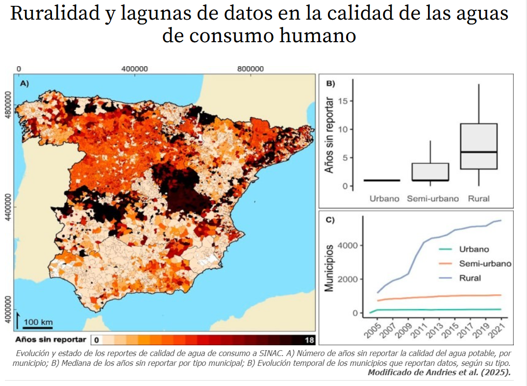
The aquifer lying beneath the Almanzora river basin could be viewed as a hydrological bank account. at the moment its balance is very low, the quality of the water isn’t great either in fact its advised that water pumped to the houses in some of the local villages is not fit for human consumption without additional filtering, so despite having running water in the taps, most if not all residents buy water in bottles or get a bowser refilled by a delivery truck on a regular basis (see this link for more detail- Ruralidad y lagunas de datos en la calidad de las aguas de consumo humano | iAgua).
The river basin in the lowest part of the valleys, and the surrounding land on the flatter parts leading to the feet of the hills they receive run-off from will guide water to the lowest points where its can be allowed to infiltrate. The makeup of the earth here determines how much water the ground can hold, the more porous the more can sink into it, and the more organic matter – the more it can hold onto for longer. Dependent on the time of the year and volume of rainwater received, the land here funnels what we see on the surface downstream but also invisibly within the ground there is hydraulic action going on. The water keeps moving where it can just on a much slower timeframe. The levels of hydrologic throughput is also affected by numerous factors, major ones being depth of the river, in this case its shallow (<300mm and flows ephemerally, the duration of continuous flow dictated by the pulse nature of precipitation and the riverbed substrate, varies from place to place, being course gravel and rocks mixed with sand in some places to a <150mm covering of hardened fine particles in others. With regards to levels of infiltration with again more variation due to the lesser understood relationship between flow rates, discharge rates and whether the accessible flowing river is connected to the deeper groundwater flow. Due to the mixture of substrates for the riverbed and the ground underneath it, I anticipate there will be mixed areas of high infiltration to the aquifer below where you have the courser large grain ground and the spots of shallow retained water within the ground supporting plant growth for longer durations into the dry spells.

Google streetview Image from the POV of La concepcion on the south side of the Rambla
Recent publications show that year upon year the groundwater levels are consistently low (The Intensive Exploitation of Aquifers and Its Implications for Sustainable Water Management in a Semi-Arid Zone (Almería, SE Spain)), and water is often transported from watersheds further north like the Negratin to supplement the failing supply here. Groundwater levels being so low also means that more advanced and expensive equipment is needed to drill down and then pump the ground water up for agricultural use. the water that is pumped up is far saltier than it used to be so its use for even just agriculture is also less effective than in times past. you need more of it to wash away accumulated salts on farmland and plants can’t make use of it all. eventually they can become nutrient locked if salinity levels get too high.
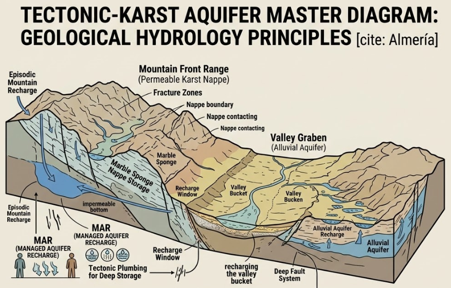
Due to the Karst aquifers here (perforated layers of limestone which over time, can dissolve via chemical action creating caves and sinkholes) making up the bedrock it means that the shallow and even deeper aquifers can be recharged if given a chance. Following periods of heavy rain such as those experienced over the winter we have just experienced, if the ground becomes saturated and enough water sits there without evaporating then the nature of the soils & aggregates - the materials that occur here affecting how they act in their saturated state will allow it seep it down through the gaps in the rocks, relieving some of that lost groundwater and raising levels. There is a lag in the time it takes for saturated soils to leach water into the aquifers which varies from region to region. But Karst limestone formations with natural routes downwards can allow for rapid recharge that’s noticeable relatively quickly. It also means that pollution can find its way into the groundwaters stored below so it’s always better to have vegetation and soils cleaning that water on its way down, and for inhabitants working the land to avoid polluting it in the first place. Should a region receive enough water and there be enough water transmission between layers, the water table rises to useable levels and can work its way through the earth for withdrawal over longer periods of time.
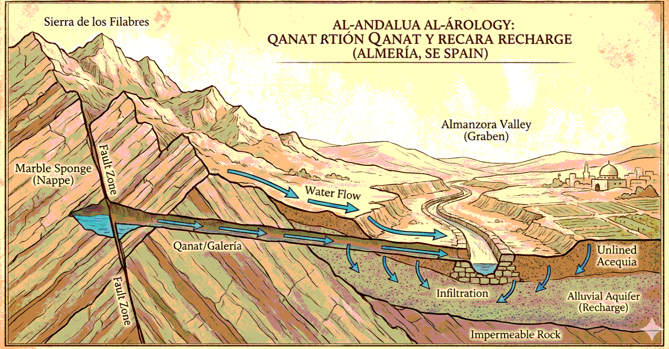
Also, in this area There are fault lines created during the nappe tectonics process which made the very hills and mountains that nurture the climate, creating our environment, and they are another key contributor to recharging that deeper aquifer underneath the shallow one capable of holding water deposited there over thousands of years. These formations of rocks look like horizontally laid slabs jutting out of the surface at an odd angle providing more routes down below the surface. These subterranean faults and cracks in the crust of the earth enable the water to move not just down vertically, but also laterally to areas you wouldn’t assume by looking at them to have any source of natural water. Once sufficiently charged with groundwater, it’s in these hidden areas that springs can emerge and small streams which then feed into surface rivers can also supply some of that stored water back out on the surface. the water had time to slowly flow through the ground unseen and more importantly un-evaporated, by rising through the ground again it can present itself as clearer almost drinkable water, perfect for tapping a spring or being used in shallow wells.
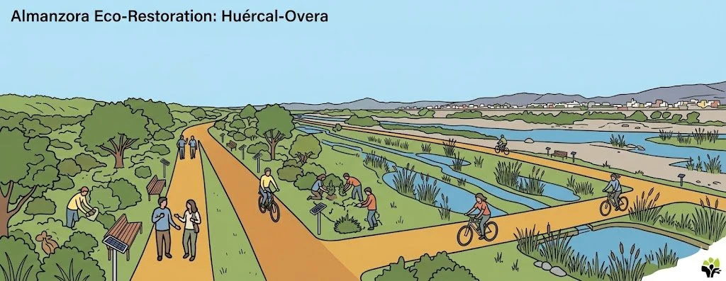
Just an idea of what could be there
The cycle isn’t performing as it could do at the moment because the missing link in the chain is the water being held in a suitable place for long enough to infiltrate deeper. By amending this part of the process and keeping the water there as long as possible, the groundwater levels could recharge.