2. Historical land use - How it shaped the hydrological function of South-eastern Spain & the Almanzora Valley
- Organically Written by a human without AI generation
Here we look at Historical land use over the course of the last few thousand years, and how it shaped the area we have inherited today. By breaking it down into 4 distinct periods it tells a story from a higher level of what happened to create the conditions we contend with.

Pre-Roman era:
From approximately 3000 years BCE, (so +5000 years ago) the inhabitants of the valley would have been Iberians, Celtic people and a mixture informally known as Celtiberians. Habitations would have been predominantly village or hamlet sized with basic levels of land being cultivated, enough for subsistence and trade in more built-up areas based on their locations on river mouths by the sea. Inland and in mountainous areas, settlements tended to be along the courses of rivers, able to build and fuel their progression from wood in the existing forests. Due to the levels of consumption in these times. It seems the balance of people’s impact on the surrounding environment was in harmony with the regeneration of nature, able to sustain the human population and absorb shocks to the environment. Even if the forests were removed at this time the changes would have been unnoticeable on a human timescale. Perhaps not even noticeable as technologies were developed at a much slower pace than they are today. Ways of life wouldn’t have changed much.
Agriculture consisted of small-scale subsistence farming and simple terraces build to take advantage of cascading water from rain passively. Very simple in structure but effective at these small scales of low intensity.
Local Hydrology of this time would have forced the people to adapt to the landscape, flooding occasionally and rivers meandering over time in their watercourses, and peoples lives reacting to the gradual movement of them.
As time moved on, and more specifically to the Almanzora basin area, the people found in the region at this time were the Pre-Algar culture, a simplistic decentralized society we can tell a lot about from archaeological information matched up with pollen count analysis and smoke particulates in sediment profiles along with artifacts found in the region from this time period. Descriptions of hamlets and villages from this period indicate that they were smaller than those found in the cultures in other parts of the mainland by the seas or along the more accessible parts of the ancient trade routes that had been established at the time.
The linguistics here differed from other populations nearby and societal structure remained tribal reflecting that of simpler bronze age societies as opposed to more advanced peoples where resources were richer and there were more interfaces with other populations. This all lends itself to a way of life that by its nature and the size of the population, the Algar people could exist in relative harmony with the land they depended on, the landscape could maintain its homeostasis supporting the number of people and quantities of nutrients and energy they needed to maintain their way of life.
Roman and Visigoth era: 500BCE -700CE
This period encompasses movements of people and culture westwards during the expansion of the Roman empire. This engulfing of the Mediterranean was widespread and brought with it massive changes in all facets of life. Known as Roman Intensification, now there were ever growing trade routes, the beginnings of infrastructure to support the growth of the Empire, cultural changes as well as the technologies imported from the far reaches of the empire which wrought chaos onto the long-balanced ecosystem the people of the area had formed part of for centuries if not millennia. With this new way of life came heavier demands on the land for its precious resources. The Naturally occurring Forests which carpeted the landscape from east to western shores were suddenly being harvested faster than they could reproduce. Land was being cleared for newer breeds and species of livestock, grasses being cultivated in their places for grazing which then prevented saplings from the seedbank of old woodland re-establishing the recently removed stands of woodlands.
The Romans capitalized on the alluvial deposits of riverine systems with their more efficient intensive farming, they consumed more wood and began mining ores for metallurgical projects, spurred on by War and conquests that we know them for. The romans brought with them their mastery of engineering at the time, controlling watercourses with their still famous drainage systems and roads. This combined change of the variables that count as an input in the wider hydrological system, change the Gross water ‘in vs out’ equation. Not noticeable by the people on the ground living and surviving, from generation to generation. Only on longer timescales we rarely view things from, because of our typical myopic views on life – can you see that over time the cumulative losses are having a detrimental effect. While it may now appear clear what was occurring, at that time prevailing belief systems were pagan in nature. People attributed events such as abundant harvests, fires, floods, and wars to the deities of their respective pantheons. This still occurs in today’s age in some cultures around the world, and to a limited extent it can work as some cultures live in harmony with their landscape and nature, believing a sustainable way of life keeps their deities satisfied and as a result they are protected by them.
The Romans also implemented widespread use of terraces and irrigation, they built aqueducts that still leave people awestruck at the scale and complexity of them, moving fresh water from locations of abundance to previously unfarmable lands, they built up infrastructure closer to the shores of the old river beds such that the farmers could take advantage of the fertile material deposited by the rivers which had been unattainable before due to the periodic flooding in times before, now able to control and divert the seasonal heavy flows away from habitations. Allowing a stable period of economic growth and relative safety overall for the inhabitants at the time. Still, these conditions would not make them impervious to 500-year floods. The magnitude of such events is overwhelming, and the only defence is to escape until they pass.
Historic records show these events have always been at the back of people’s minds, as something inevitable that we live in fear of but perhaps don’t quite expect to happen to us.
Islamic Al-Andalus: 700CE – 1300CE
The Moorish conquest and occupation brought with it influences from the middle east- a region borne of low rainfall, and high evaporation meaning the peoples and the culture itself are built around surviving and thriving with little input in terms of precipitation. Their architecture was significantly different, they brought with them the famous qanat systems, relics of which still exist throughout the Mediterranean and middle east today and still work. Similar to Roman aqueducts they are capable of transporting precious fresh water across vast distances, the difference between them being they are underground with access pits regularly along the routes. These systems by their nature are protected by the earth itself from evaporation, and from damage by inhabitants cannibalizing the infrastructure for building materials like the aqueducts and from vandalism or sabotage by invaders of the incumbent empire.
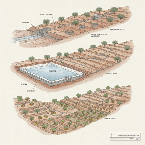
Illustrations of what the Hydrological earthworks could have looked like.
Acequias—open air irrigation channels introduced during the Roman era—were further improved in this period with new technologies that elevated water and minimized evaporation. These enhancements supported the cultivation of valuable crops like sugar cane, Citrus, cotton, rice, artichoke and spinach. The city of Almeria grew in this time, and the cultural imprint is still visible today with many place names still reflecting their Islamic origin (all the places beginning with ‘Al’ as a rule of thumb). The cities grew on the collective distribution and water rights that came with their societies structure are a key indicator of how their attitude to water management influenced the way of life here in these times.
The degraded land rebounded in this period relative to those immediately prior, dry farmed terraces could now infiltrate more water and return some of the depleted groundwater for centuries, allowing natural restoration where land was allowed to breathe.
The negative effects of the changes implemented in this time, are that when the Islamic age of Spain ended, and their forces were expelled from the continent, the infrastructure wasn’t maintained in many instances, perhaps knowledge was lost and stewardship ended as newer populations moved back in. The infrastructure wasn’t and never is 100% passive. So, it reverts to a less positive baseline which means a return to heavier erosion, flood damage etc. This is most unfortunate but a part of the past people have had to adapt to and live with. Undoubtedly though some of the improvements and great architecture as well as simple earthworks, and knowledge became part of the new inhabitant’s culture. Remnants of the Al-Andalus Balsas (cisterns and storage basins) & Boqueras - earthworks that spread water over flatter terrains in flood plains and managed flood waters remain in some places and the town locations themselves all show signs of hillforts and high central locations with the irrigated lands below hugging the watercourses.
Reconquista – Modern age era, 1300-Present day:
The headlines of this era are centered on the loss of maintenance of systems that worked for centuries losing their maintenance, and any hopes of expansion. The knowledge and stewardship disappeared with focus placed on re-population with Christian Spanish people. Political turmoil interspersed with the usual environmental extreme events over the expanse of time meant the land reverted to being prone to flash flooding when the heavy rain came, the infrastructure that was once capturing the waters using the problem itself as the answer, to towns and farms being hit, and rebuilding after. Each time more old earthworks being lost, making way for modern adaptations.
The population always growing along with technological advancements needed quicker higher impact answers, so we see the implementation of basins, water transfer canals and pipelines and desalination plants as the new hydrological infrastructure. Mining operations with increasing water demands and little care for the effluent they produced require huge amounts of fresh water to push the pollution downstream, whilst salinating the land. Use of deep bore wells and pumps now drive groundwater levels ever lower, meaning the price of extraction of the water is always increasing too, and a side effect nobody anticipated is that of the hydrological pressure from the sea’s salty water becoming higher than that of freshwater aquifers. This leads to land becoming salted by the sea as it pushed inland, making land infertile and groundwater un-drinkable, and no good for irrigation.
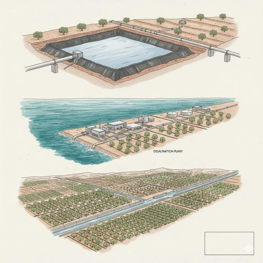
Current methods of irrigation and desalination are energy intensive; energy production is water intensive. The spiral into hydrological insolvency is well and truly underway, and the advent of tourist resorts, luxurious homes and intensive manufacturing is only making it worse. On top of that we have introduced the requirement for data centers, which require intensive freshwater for cooling, construction and operation. This is currently a growing requirement on scales never seen before by mankind, almost a lagging effect of Moore’s law as compute is the currency of AI of which demands are growing exponentially in the technological arms race that it has imposed on us.